Continued from part 4:
From Zapala instead of following ruta 40 we chose the less traveled ruta 46 as far as the Laguna Blanca. We were in the northwest ends of patagonian steppe (which extends to the Atlantic), in places wild, solitary and bare, where winter lasts seven months with average temperatures that barely reaches 3 ° C. And although theoretically our presence there was summer, the conditions were overly winterish for someone who comes from the Mediterranean. Until Rahue we had drizzle with a particularly icy atmosphere, with a heavy gray sky and of course the wind was constantly in full swing. But I could not have imagined that part of South America dressed otherwise, under a bright sun for example. The northwest patagonian steppe had to be exactly like we found it.
By the time we joined ruta 23 to Junin de los Andes, we were quite close to the eastern slopes of the Andes and that meant going to another ecosystem. The steppe was the past and we watched the landscape change, the road flowing next to rivers, fertile meadows and farms, with the gauchos riding their horses to marshal flocks of cows. There and in all the other major grasslands of Patagonia is where the best beef steak in the world is produced.
[imgslider-wrapper]
[imgslider imgurl=”1873″][imgslider imgurl=”1874″][imgslider imgurl=”1877″]
[/imgslider-wrapper]
The road had stretches of bitumen and good flat dirt, which despite the rain that was constantly coming down on us never formed much mud. Few were the places where there were large concentrations of fluvial stones demanding a somewhat slower pace.We entered the national park Lanin and the transformation of nature was now complete. A riot of green hues, coniferous forests, araucaria, and other species found only in that corner of Argentina. Lakes and rivers laid out to our right and our left, as we rolled onto the gravel roads of the park.
We arrived at the picturesque and beautiful San Martin de los Andes, which is located on the shores of Lake Lacar, inside the park. An incredible location. A stop at the village for a hot coffee and some hot chocolate was much needed. We were soaked, the downpour was endless. Ruta 234 brought us to another park, the Nahuel Huapi. The area is known as the Lake District of Argentina. We were experiencing a playback of the scenes of the previous days: the landscape was of incomparable beauty, and the weather was brutal. We managed to cover only 130 km one day before having to stop in Villa Angostura out of necessity, since the rain was torrential for 3rd consecutive day.
Our course brought us again on ruta 40 and into the province of Chubut. Shortly after El Bolson we exited to ruta 71 that brought us on dirt and gravel roads to the amazing National Park Los Alerces.Despite the rain and the bitter cold that persisted for a fourth straight day, the park Los Alerces reserved for us a gorgeous spectacle, one of those that calm your soul and make you forget everything. Turquoise lakes. Huge trees like giant sequoias, the Alerces trees, which obscure the light of day. By looking around we see that nature is at its best, making us wishing we were artists because only an artist could describe the magic of Los Alerces.
[imgslider-wrapper]
[imgslider imgurl=”1875″][imgslider imgurl=”1876″][imgslider imgurl=”1878″]
[/imgslider-wrapper]
On the bank of the lake Futalaufqen we found a sheltered spot and camped. The sky cleared and a magical atmosphere spread around the lake. Maravillosa Patagonia, maravillosa Argentina. The ruta 71 is dirt for 19 kilometers and then as it exits the park Los Alerces asphalt continues until the small provincial town Trevellin, where we turned west to Chile on passable dirt roads. After the border we stopped at Futaleufu village for supplies.
We passed Villa Santa Lucia and we joined one of the most famous tracks of Patagonia. The Chilean ruta 7 or better known as «Carretera Austral» opened before us, and it was as if a nature’s blockbuster show was starting. Dense forests, turquoise lakes (again), glacier views on the slopes, waterfalls. At some points, it felt like jurassic park. At some other points the devastated landscape because of the eruption of the Chaiten volcano a few years back gave the feeling of a no man’s land. At other spots, the dense fog that covered everything, gave way and through it appeared segments of the damaged forests from the pyroclastic flow of Chaiten, and then all became otherworldly beautiful. The weather that turned into hell could do nothing to reduce the euphoria that this awesome place had caused to us.
Leaving Coyhaique, at the pass of Cerro Castillo we saw the thermometer dipping to zero but noticeable temperature because of the rain was tragically worse. I do not remember feeling so frozen even when we rode to paso Sico and the temperature was at -8o C, very early in the morning, some three months ago in the central Andes.
[imgslider-wrapper]
[imgslider imgurl=”1879″][imgslider imgurl=”1880″][imgslider imgurl=”1881″][imgslider imgurl=”1882″]
[/imgslider-wrapper]
Our next stop was in Puerto Tranquillo, a small village on the western shore of the huge lake Lago General Carrera, which has been known for a single reason, the “Capillas de Marmol”: about 3-4 km west of the village, the lakeshore forms a small peninsula. The finish is made of solid marble which is carved in a way that only nature knows, forming a beautiful network of caves, tunnels and marble monoliths, colored magically by reflections of light on water. A boat ride there is a must.
We left Carettera Austral a few kilometers further south, and we turned west towards again to Argentina, riding next to Lake General Carrera. We arrived at the border town of Chile Chico where we spent Christmas. We did approximately 600 kilometers on the Carretera Austral, of which most of them on gravel roads and it was one of the most amazing rides we have ever done.
[imgslider-wrapper]
[imgslider imgurl=”1883″][imgslider imgurl=”1884″][imgslider imgurl=”1885″]
[/imgslider-wrapper]
Once in Argentina, we catched again the ruta 40. This road, which runs throughout Argentina from north to south for more than 5000 km, is synonymous with adventure and carries a fame of danger. I think it derives from earlier times and travelers of the past, when the Ruta 40 was a really a remote road from end to end, all gravel, and when the infrastructure along the way was really rare and scattered among enormous distances. So it had to be a real challenge to do the entire crossing with a motorcycle. This heritage is still carried today, although now the situation is different. Easier. Very large parts of ruta 40 are now paved. However, there are two areas that still retain some of the reputation of the most difficult ride in Argentina. One is in the north, in the province of Salta. Passes from the San Antonio de los Cobres (we had visited before 3 months). The second is to the south and it was the one we were going to cross that day. From Bajo Caracoles, 125 km south of Perito Moreno, to the Tres Lagos, 335 km further south from that.
Firstly, there is no gas station in this stretch of gravel. The second parameter is that in that huge, flat and vast expanse, the winds that blow from the west is often so strong that result, in a big increase in fuel consumption. The intensity of the winds in this area has added an extra touch of fear to the reputation of Ruta 40, claiming many falls and seriously injured riders. We had information that several stretches of that path, especially the last 40 km before Tres Lagos were very difficult, with very large and deep gravel.
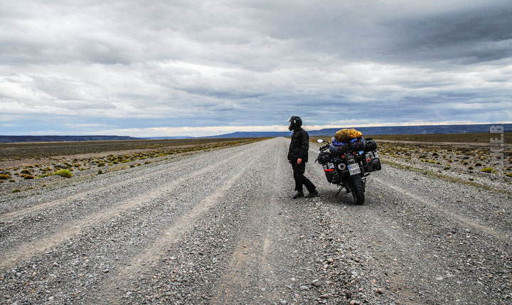
But we were lucky. In Bajo Caracoles the gas station was open. The paving projects along ruta 40 had progressed, and finally the wind gave us a break as it was almost absent!. The segments with the deep gravel were much less than expected. We managed to cover the whole distance of 540 km from the border to the Tres Lagos in a day, although the last half hour we rode almost at dark. We spent the next few days in El Chalten, at the foothills of the mighty impressive Fitz Roy mountain. Then we arrived in Calafate where we spent more days relaxing. Besides, it was now new Year’s Eve ! We visited the fantastic glacier Perito Moreno that held for us a superb display of nature’s wonders.
[imgslider-wrapper]
[imgslider imgurl=”1887″][imgslider imgurl=”1888″][imgslider imgurl=”1889″]
[/imgslider-wrapper]
On January 2nd 2013, we departed. We rode south and we entered Chile. Our next destination was the Torres del Paine national park. There we explored this great landscape, riding on a circuit of 150 kilometers of dirt roads, admiring the 3 massif granite towers that dominate the landscape.
[imgslider-wrapper]
[imgslider imgurl=”1890″][imgslider imgurl=”1891″][imgslider imgurl=”1892″]
[/imgslider-wrapper]
The time had come, that we were about to reach the final stage of our Journey. The land of fire was next!
(Images courtesy of John Kapelakis & Elena Bitsika)